“
I have visited sacsayhuaman countless times and it still amazes me. Not only for the zigzag walls and cyclopean blocks, but also for the sweeping view over Cusco and how easy it is to reach from the center. In this blog I cover the essentials to plan your visit without wasting time: how to get there, what to see, tickets, best time, curiosities, and nearby routes.
”
What Sacsayhuamán is and why it impresses
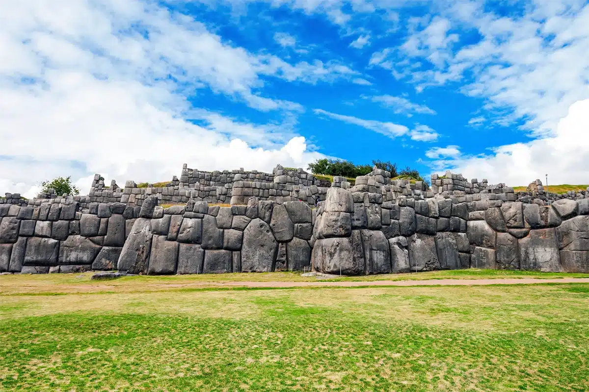
Sacsayhuamán is one of the most emblematic archaeological complexes in Cusco. It sits about 2 km from the historic center on an elevated terrace with privileged panoramas. When I go up, I like to pause a minute in silence: the wind flows, the city spreads below, and stone dominates the scene. The three zigzagging terrace-walls are striking. The scale is clear: multi-ton blocks fit with precision. Ceremonial spaces and the large esplanade where cultural events are held today also stand out. If you want a travel summary in a few lines: it is living history, stone engineering, and photo-worthy views in one place.
Temple or fortress?
The recurring question: was it a temple, a fortress, or both? The most sensible answer combines functions. The strategic location suggests defense and control of the surroundings. Iconography, design, and links to festivities point to a ceremonial role. Every time I return I confirm that duality: the military is in the layout and the sacred in the atmosphere. For visitors, it matters less to settle the debate and more to walk with attentive eyes: look at the angles, the enclosures, and how the whole dialogues with the landscape.
Where it is and how to get there from Cusco’s center
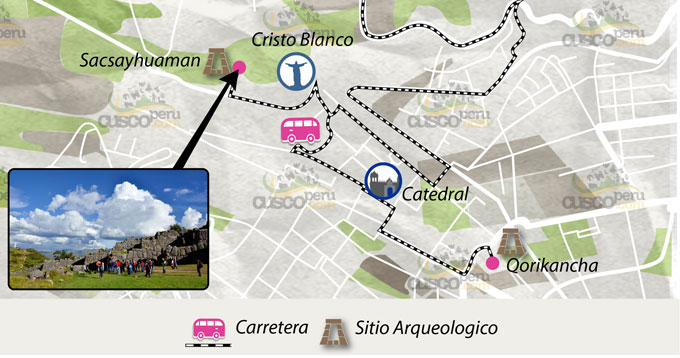
Sacsayhuamán is very close to downtown. From the Plaza de Armas you can go on foot, by taxi, or combine both. This proximity makes a quick 2-hour visit feasible or a more relaxed walk with photo stops.
Walking route, taxi, and real times
On foot, the climb is short but steep. I usually go up via Sapantiana or San Cristóbal and in 25–35 minutes I’m on the esplanade. By taxi from downtown, the ride usually takes 10–15 minutes depending on traffic. If you prefer apps, ask to be dropped at the main gate and plan to walk back down while enjoying views over Cusco. Tip: in strong sun, bring a cap, sunscreen, and water. In the rainy season, the ground can be slippery; good-grip footwear makes the difference.
Distances and times from the Plaza de Armas
- Plaza → main access: ~2 km.
- Easy walk: about 30 minutes.
- Taxi: 10–15 minutes depending on traffic.
Reference costs and taxi apps
- Standard city fare. Check the app when requesting the ride.
- Consider round trip if you plan to stay until sunset.
Cristo Blanco viewpoint and the city panorama
From the Cristo Blanco the panorama is broad and faces sacsayhuaman and the city. More than once I’ve gone first to the viewpoint to photograph the zigzag walls and then walked down to the complex. The best time for photos is often the afternoon when side light brings out textures; at sunrise you get clear air and few people.
Best time for photos and safety
- Sunrise: soft light and low crowds.
- Afternoon: strong textures and golden skies.
- Stay on paths. Keep gear and valuables discreet.
What to see inside the complex
At sacsayhuaman it’s not all walls. There are corners full of history and stonework details you should spot so you don’t miss them.
Towers, bastions, and the Inca Throne
Spend time walking the terraces and the bases of the former towers. The bastions give strong leading lines for photos. The so-called Inca Throne is a staircase carved into living rock with surprising polish. When I host friends, I do a “60–90 minute loop”: walls, bastions, throne, esplanade, and a pause to notice how blocks align at the corners.
Suggested 60–90 minute route
- Initial viewpoint and zigzag orientation.
- Lower terrace and bastions.
- Throne and polished rock area.
- Main esplanade and panoramic shots.
Chinkanas and the “rodadero” Suchuna
The chinkanas are short passages now open as small attractions. The “large chinkana” feeds legends of long tunnels to the city center. Separate myth from practice: stick to open areas only. Next to it is the rodadero or Suchuna, a polished formation where kids love to slide. I recommend caution, especially when the ground is wet.
Access tips and precautions
- Stay within signed areas.
- Avoid slips on polished surfaces.
- No flashlight needed on official routes.
Curiosities
1. Cyclopean blocks and tight joints: how they were carved
Dry joints were achieved with patient dressing, testing, and refitting. Look for quarry marks and multi-face contacts. Finish is not uniform: some sectors are finely polished, others show rougher tool texture. Picture the logistics: quarry selection, rough-out, transport, and final fit on site.
2. Zigzag walls and possible lightning symbolism
The zigzag recalls Illapa, the lightning deity, in Andean worldview. The pattern also dissipates energy and spreads loads, aiding stability. Form and function can coexist.
3. Quarries, transport, and tool marks
If the “stone route” interests you, look for associated quarries around Cusco. Some pieces show cut traces, others burnished faces. Great subject for close-up photography.
4. Alignments, acoustics, and “echo” spots
Test the acoustics on the esplanade and near certain walls. There are points with curious echoes. Natural physical effects that add a sensory layer to the walk.
Mysteries
1. Tunnel legends and the large chinkana: myth vs. reality
Stories speak of tunnels connecting to the historic center. Today there are no tourist routes through extensive underground passages. Stay on official paths and enjoy the legends as local folklore.
2. Intentional astronomical alignments?
Possible relationships with solstice sunrise and sunset are observed in some seasons. There is no full consensus on whether they were deliberate or terrain coincidences.
3. Protrusions or “ears” on some blocks
Several stones show lugs that could have served for handling or lifting. Their exact function—and whether they were left as aesthetic or technical features—remains debated.
4. Acoustics: design or accident
Echoes and sound focal points are perceived in parts of the esplanade and walls. It remains to be confirmed whether acoustics were calculated for rituals or are casual effects of geometry.
5. Exact origin and haul routes of certain megablocks
Quarries have been identified, but the precise route of some blocks and the detailed transport logistics are still the subject of technical hypotheses.
6. Fine-grained construction sequence and chronology
Phased construction is accepted, but pin-point dating by stages and work crews is not settled. Overlapping styles complicate a definitive timeline.
Tickets, hours, and best time to visit
To enter sacsayhuaman you need the Cusco Tourist Ticket. This ticket groups several sites and is sold in circuits with defined validity. Before you go, check current terms at official sales points in Cusco.
Cusco Tourist Ticket: types and where to buy
- Ticket types: full and circuit-based.
- Does it include sacsayhuaman? Yes, within the corresponding circuit.
- Where to buy: authorized offices in Cusco and marked points.
- Tips: bring ID and verify validity to plan Q’enqo, Puca Pucara, and Tambomachay on the same day.
Differences between circuits and validity
- Full: more sites and more days.
- Partial circuits: fewer sites and shorter validity.
- If your plan is sacsayhuaman circuito 1 qenqo puca pucara tambomachay, calculate time and transport.
Hours, weather, and light tips for photos
Visiting hours are daytime. To avoid crowds and harsh sun, go early or after 3 p.m. In the dry season (May–October) you get clear skies; in the rains (November–April), dramatic clouds and intense greens.
Dry vs. rainy season by month
- Dry: cold mornings, intense midday sun, golden afternoons.
- Rainy: intermittent showers, changeable skies, occasional rainbows.
- Clothing: light layers, windbreaker, hat, and sunscreen year-round.
Festivities and nearby experiences
Inti Raymi and other events
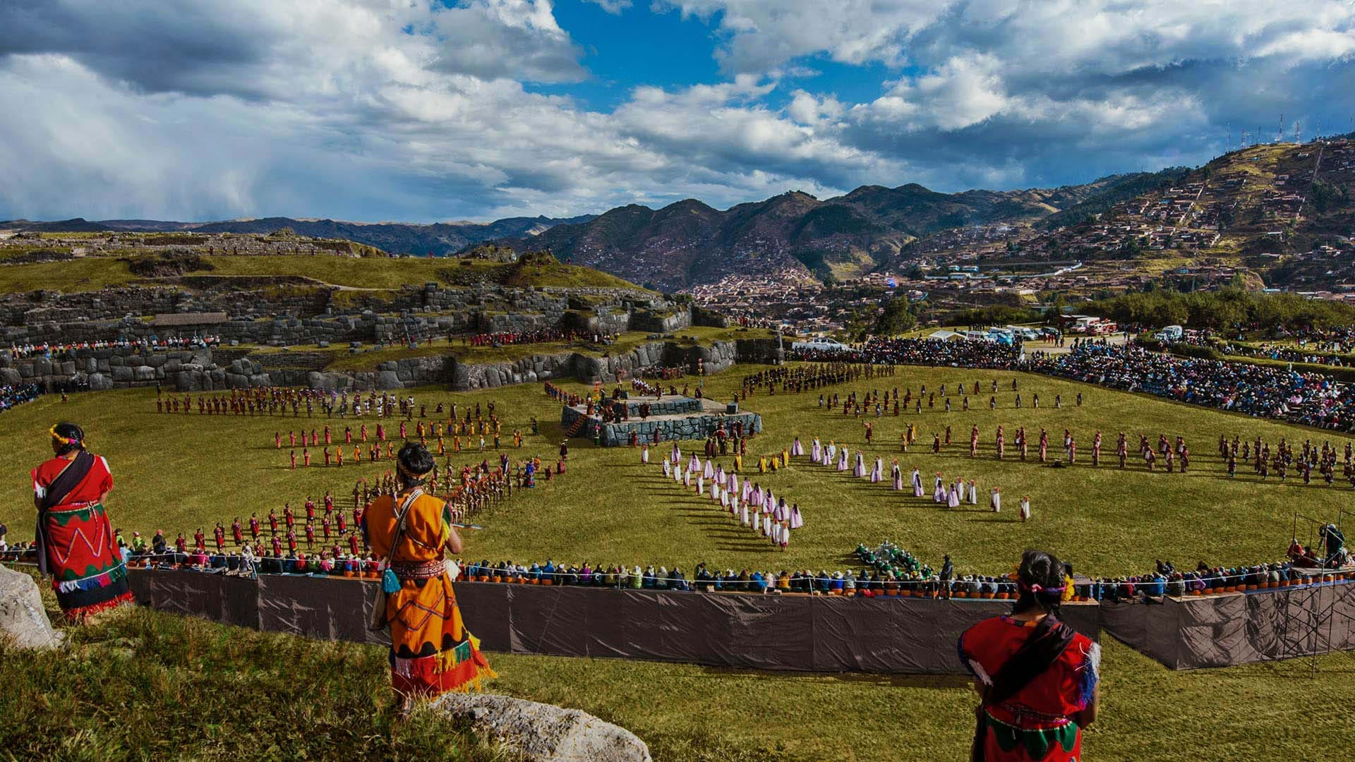
On the sacsayhuaman esplanade the Inti Raymi takes place every June. Logistics change due to temporary stages and grandstands. If you travel on those dates, buy tickets in advance and arrive early. Other events such as Warachikuy occur on different dates on the cultural calendar.
Dates, access, and capacity on the esplanade
- Seasons with controlled capacity and numbered seating.
- Limited tickets and partial area closures.
Circuit I: Q’enqo, Puca Pucara, and Tambomachay
With the same ticket you can link these sites. I usually suggest half a day: sacsayhuaman early, then Q’enqo, Puca Pucara, and finish at Tambomachay. A compact route with varied landscapes and fine stonework.
Half-day itinerary linking sites
- 08:00 Sacsayhuamán
- 10:30 Q’enqo
- 12:00 Puca Pucara
- 13:00 Tambomachay and return to Cusco
Final tips for a smooth visit
What to bring, what to avoid, and basic rules
- Water, sunscreen, hat, and sunglasses. Altitude and sun are strong.
- Shoes with good tread. Some surfaces are polished.
- Respect paths and signage. Do not climb on walls.
- Avoid drones without permits.
- Photography: shoot RAW on camera; on mobile, enable HDR at sunset.
- If visiting with kids or older adults, plan breaks and shade.
- Pack out your trash. Keep the site clean.
Conclusion
Sacsayhuamán condenses history, engineering, and landscape minutes from downtown. In my experience, no matter how many times I go, I always find a new angle, a different echo, or light that transforms the stone. With this guide you cover the essentials: how to get to sacsayhuaman, what to see, tourist ticket, hours, curiosities and mysteries, and how to link the nearby circuit without rushing.

